
Glacier Point Road is a sixteen mile parkway that weaves its way through thick forest while constantly climbing its way up to Glacier Point. The road curved more than a rattlesnake. We passed a turn for the Badger Pass Ski Area, which is only open in winter. We also passed a campground and a couple of trailheads before reaching Glacier Point at the end of the road.
We parked in a large lot and got out to see the famous views. I was with my friend Joe and his wife Kate (girlfriend at the time). The three of us made the short walk together along a few interconnecting paved walkways towards Glacier Point. The paths led to a handful of viewpoints, but we decided those could wait until after we reached Glacier Point, which we read had the best view of all. Within a few minutes we were there.
Glacier Point sits atop the edge of the sheer southern wall of Yosemite Valley, directly east of El Capitan. At an elevation of 7,214 feet, we were 3,200 feet above the valley floor and eye-level with some of the most stunning scenery in the world. Directly beneath us was the wondrous valley. It was green and narrow, stretching from east to west. I could barely make out the Merced River, cutting a course through the sea of green.
Just to the northwest of where we stood and only a few hundred feet below us was the top of Yosemite Fall. I watched in awe as the tallest waterfall on the continent plunged down to the valley floor. The view from Glacier Point was truly a bird’s eye view. I felt like I could have been looking down from a hot air balloon and still not been as high up as we were.

El Capitan spanned the view to my left. The gigantic chunk of granite towered above the valley. As high up as we were, El Capitan was still taller. I imagined rock climbers scaling its smooth vertical wall. They would appear as mere specks from where we stood.
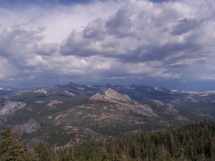
Even better views were due east. Half Dome towered over the rest of the high sierra, filled with gray mountains and granite domes. The iconic symbol of Yosemite was more than 1,500 feet higher than our vantage point at Glacier Point, yet it protruded so proudly from the rest of the landscape that it looked as if we could reach out and touch it. We shared the same view of Half Dome as those in the valley, showcasing the profile of its sheer northwest face.

In front of Half Dome was the thin and verdant Tenaya Canyon, enclosed by steep-sided cliffs. Beside Half Dome the Merced River flowed over the Giant Staircase. That is the name given to the geologic formation that bears the two amazing waterfalls that deliver the Merced to Yosemite Valley. First the river descends through Little Yosemite Valley, then explodes off the top of Nevada Fall, and finally drops off Vernal Fall to the valley floor. From Glacier Point we could see it all. Seeing Vernal Fall and Nevada Fall in the same view was spectacular; they were both so powerful and beautiful. They looked incredibly smaller from there than the last time I had seen them, along the Mist Trail.

The entire panoramic scene was stunning in every direction. The oohs and aahs of the tourists and the constant clicking of camera shutters were almost overwhelming. The view rivaled any other in Yosemite, maybe anywhere across the world.
We remained at Glacier Point for a while, admiring the immaculate views. I strolled from viewpoint to viewpoint taking plenty of photos. We eventually headed back to the car.
We didn’t have to go far, as there were several hiking opportunities near Glacier Point. Instead of choosing one of the more strenuous trails heading down into the valley, we opted to drive a couple miles down Glacier Point Road to the Sentinel Dome Trailhead. We wanted to do an easy hike there, then a harder hike the next day in the high sierra, before tackling Half Dome the following day.
We parked in the small lot and walked past a bathroom to the trailhead. Two different hikes begin there. Sentinel Dome is one option, Taft Point the other. Both hikes are just 2.2 miles round-trip and both are rather easy. Taft Point gains about 200 feet whereas Sentinel Dome gains double that. While the Taft Point Trail leads to an impressive viewpoint overlooking Yosemite Valley, the Sentinel Dome Trail leads to the top of a granite dome providing panoramic views of the High Sierra.
On a whim we decided to take the right path, which took us to Sentinel Dome. The trail wasn’t especially scenic along the way, but it was short, easy, and had incredible views from the summit.
Soon after we began the hike we crossed a small bridge that spanned a stream. From there we traversed gently ascending granite. Then the three of us followed the path into a forest of pines and firs. Large boulders littered the forest floor and the approach to the large round hump of the dome itself.
The next part of the trail followed an old paved road up the dome. The road was closed to automobile traffic, but used by hikers. We followed it up Sentinel Dome’s east face beside wind-swept bushes and stunted trees.
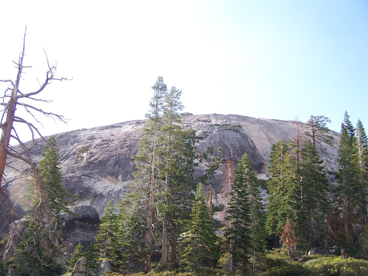
The final push was a climb up the steepest portion of the dome. The trail essentially dissolved into the granite, but we knew we had to continue up in order to reach the summit. The short scramble amidst boulders only lasted a couple hundred yards. Then we were atop the second highest point in Yosemite Valley. Only Half Dome is taller.


The top of the dome was generally flat, but rounded near its edges. It was mostly open, with some boulders strewn about. A gnarled and twisted Jeffrey Pine lay near the center of the summit. It was several hundred years old before it died during a drought in the 70s and it finally fell over a few years ago. The white and weathered tree blended in with the color of the dome itself.

The ancient tree was fascinating, but the views around it were phenomenal. To the north and west were views of Yosemite Valley far below. Farther to the west was the Merced River Canyon and beside the valley to the north was the massive El Capitan. Nevada Fall and Half Dome were to the east. The summit of Half Dome is only a few hundred feet taller than that of Sentinel Dome. It looked bigger than ever since it was only a short distance away. Behind Half Dome was Cloud’s Rest, a large gray mountain. The entire 360 degree panorama from the summit of Sentinel Dome was sensational. A plethora of granite domes and peaks surrounded us. It was as if the entire High Sierra region was within reach.


Nice post, Matthew. What a special place. My memory of Glacier Point was rather vague as it had been over 15 years since David and I were at Glacier Point. Digital camera was in its infancy and a compact storage card had very little capacity. I think David was using a digital camera with a whopping 1+ MB resolution while I was still lugging around my SLR. You had great memory about the places you visited. Your description of the place in this post brought back my fond memory of Yosemite. Thanks for sharing.
LikeLiked by 1 person
Thanks so much Keng! I journaled on most of my National Park trips, which has been a huge help in blogging about things from the past. And some posts I’ve taken right from my book. Im jealous of all the traveling you’re doing now.
LikeLike
I love Yosemite, and Glacier Point was one of our favorite stops. I didn’t get to hike around there, I will try to next time, looks so beautiful. I loved your picture of the weathered pine!
LikeLike
Thanks. I think I might have to try the hike from Glacier Point to the valley when I make it back there or vice versa.
LikeLike
I have lived in California all my life and I am finally visiting Yosemite this weekend. I loved reading your post!
LikeLike